Ground Penetrating Radar Services
Safe Site utilizes mapping grade GPS data collectors to acquire utility location data, providing customers with a permanent record of site utilities.
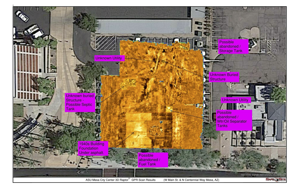
We locate the unknown
Our GPR technology can detect traditionally non-locatable subsurface utilities and structures, such as:
- Non-Metallic Utilities (e.g. PVC, Asbestos Cement, Concrete Storm & Sewer Systems)
- Abandoned Utilities
- Underground Storage Tanks & Voids
- Buried Features & Structures (e.g. Manholes, Vaults, Valves)
- Utilities with broken or damaged tracer wire

We are the utility locating & damage prevention experts
Safe Site Utility Services is Arizona’s leading provider of advanced Ground Penetrating Radar (GPR) solutions in Arizona. Whether you’re in the pre-design, design, or construction phase, our state-of-the-art GPR technology provides unparalleled insights. We offer a range of options, from cost-effective 2D radar ideal for smaller areas to comprehensive 3D radar solutions that cover all your needs. Our commitment is straightforward: We’re here to help you achieve exceptional results, whether you need to locate known utilities, investigate abandoned ones, or uncover unknown utilities and buried structures. Our goal on every project is to identify all utility conflicts so there are no surprises during construction. Contact us today and let us know how we can assist you with your project.
Why GPr?
Benefits of 2D Ground Penetrating Radar:
- Cost-Effective: Offers a budget-friendly solution for targeted or smaller areas of investigation.
- Rapid Data Collection: Provides real-time results, making it suitable for quick decision-making in specific locations.
- User-Friendly: Simple operation and interpretation, suitable for operators with varying levels of experience.
- Effective for Focused Areas: Excels at identifying objects and anomalies within limited, predefined areas.
- High Resolution: Delivers detailed, high-resolution images of the subsurface in the selected investigation zones.
Benefits of 3D Ground Penetrating Radar:
- Comprehensive Area Coverage: Provides a complete three-dimensional representation of the entire surveyed area.
Improved Depth - Perception: Effective at identifying objects and anomalies at greater depths throughout the entire area.
- Enhanced Accuracy: Precisely locates and maps non-metallic objects within the entire scanned region.
- Reduced Ambiguity: Minimizes false positives and negatives, increasing the reliability of results.
- Advanced Software Tools: Includes sophisticated software for in-depth analysis, modeling, and visualization of the entire surveyed space.
- Better Planning and Design: Assists in planning construction or excavation projects with a holistic understanding of the subsurface environment.
- Environmental Applications: Valuable for mapping geological formations, detecting buried contamination, and monitoring subsurface changes across the entire area.
- Utility Mapping: Useful for mapping non-metallic pipes and cables, especially in complex urban environments.